General Overview of Data Integration Strategies
Integrating data into webGIS applications is a core aspect of building a functional and informative map. Maplibre, the engine underpinning MapComponents, provides robust support for various data formats. Understanding the formats it works with natively and how they impact performance is crucial for effective data integration.
Supported Formats by Maplibre
Maplibre natively supports a range of formats for map data, including:
- Vector Tiles: Highly optimized for performance, allowing for smooth zooming and panning at various scales.
- GeoJSON: A versatile, easy-to-use format that's excellent for small to medium-sized datasets.
- Raster Tiles: Useful for satellite imagery, height maps or pre-rendered map tiles.
- Image Sources: For overlaying single images, such as historical maps.
Performance Considerations
The choice of data format can have significant implications for the performance of a webGIS application:
- Vector Tiles are the preferred choice for performance, especially with large datasets. They allow for dynamic styling and efficient data management, enabling the map to load and respond quickly.
- GeoJSON is more straightforward but can lead to performance bottlenecks with large datasets, as the entire dataset needs to be loaded and rendered client-side.
Transforming and Loading Data
Regardless of the source format, data often needs to be transformed into a format that Maplibre can consume. Here are general steps to handle this process:
-
Data Transformation:
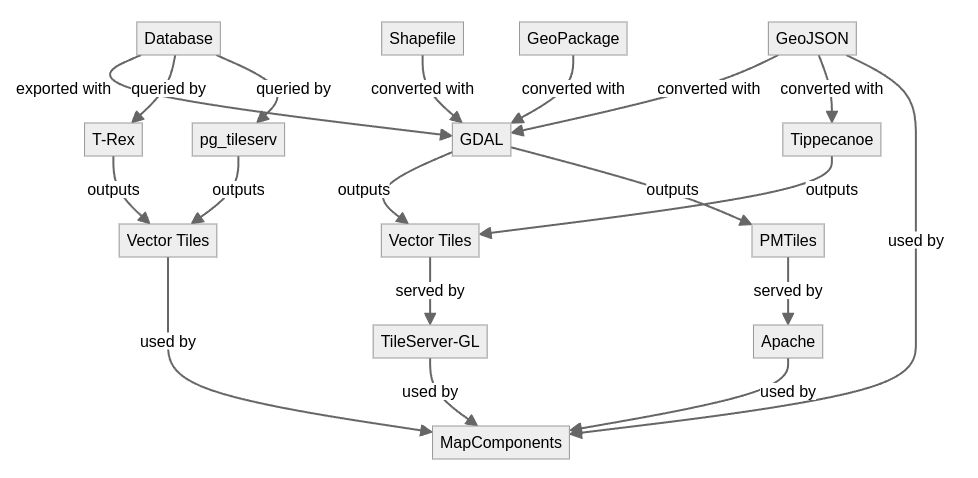
- Convert your data into one of the supported formats. For instance, shapefiles (SHP) can be converted to GeoJSON using tools like GDAL.
- Optimization may be necessary for performance, such as simplifying geometries or reducing precision. Vector tiles offer simplified and reduced geometries for lower zoom levels increasing the precision and amount of geometries with increasing zoom levels.
-
Data Hosting:
- Host the transformed data. Vector tiles as mbtiles can be served using a tile server, while GeoJSON files and vector tiles as pmtiles or tile pyramid can be hosted on any web server.
-
Map Integration:
- Utilize Maplibre's API to load the data into your map instance. This involves adding a MapComponents LayerComponent and corresponding configuration.
- For dynamic data, consider using web services such as pg_tileserv, t-rex a django backend to fetch and update data in real-time.
-
Performance Optimization:
- For GeoJSON and other formats that are rendered client-side, keep a close eye on file sizes and the number of features.
- For vector tiles, ensure your tile server can handle the load and delivers tiles efficiently.
By understanding the capabilities and limitations of each format, and through careful data transformation and optimization, one can achieve an efficient and responsive webGIS application using MapComponents.